Prin 2010-2011 – PROGRAMMI DI RICERCA SCIENTIFICA DI RILEVANTE INTERESSE NAZIONALE
Post-Metropolitan Territories as Emerging Urban Forms: the challenges of sustainability, habitability and governability. – Politecnico di Milano, Faculty of Architecture – Department of Architecture and Urban Studies and other Italian Universities
In the first phase of the research, about the construction of the Atlas of urban transformations and its criteria, my contribution has helped the definition of parameters and indicators helpful in studying and reading the most recent phenomena of urbanization throughout the region around Milano. The Atlas has been recognized as an exceptional result of the research and a new cooperation with Regione Lombardia started immediately to support future analysis on the same matter.
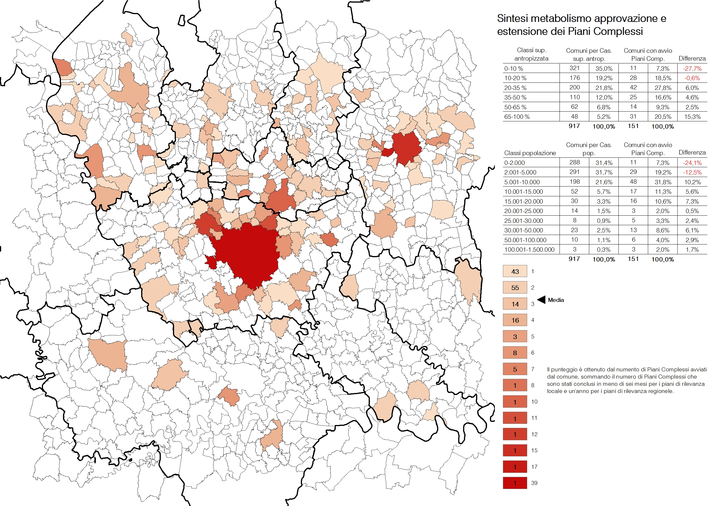
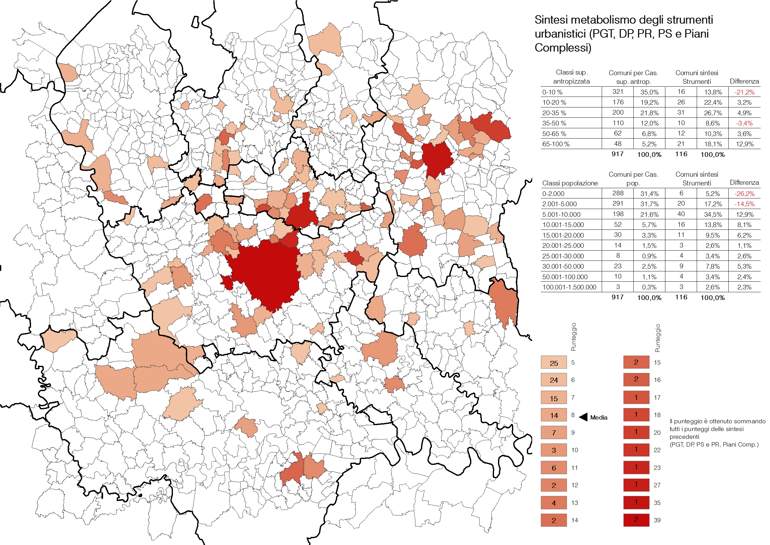
The second phase of research during the second and third years, allowed my research team and myself to analyze and define the relationship between the design of plans and projects and the transformations of the environment, while questioning whether in previous years there had been a presence of specific groups of transformations and changes depending on the combination of planning tools in force. By analyzing the segment (the surrounding of Milan) that the Milanese team is responsible for, my work consisted in mapping all urban planning tools produced in recent years in each county and, simultaneously, cross-referencing the data with other territorial changes such as the effects of the economic crisis (which deeply affected certain dynamics of urban evolution), the realization of works of extraordinary development in the landscape (such as the large, new, regional motorways) or the occurrence of exceptional events (Expo). The goal was to identify the existence of reoccurring behaviors (speed and product type in the landscape) depending on the combination between the plans, the regulation and the opportunities at hand. In conclusion, the research spans between the end of 2015 and the early months of 2016, with the presentation of the results of the individual research teams, following the publication of the Atlante as a result of the first years of research and, with regard to the coordination of my research team, demonstrating the existence of urban metabolic details in contexts that are not necessarily urban, but urged by transformative trends that don’t necessarily reference the city.
Results by the research team: the coordination of the research team completed its tasks with the conclusion of the research. A proposal was submitted, accepted and an article, due to appear in one of the next issue of Urbanistica, is in the process of being published. The research also is in the process of being published. The Atlante, a result of the first phase, has given rise to an agreement with the Lombardy Region on behalf of the DASTU.
The results of my research, as coordinator of the team in charge of studying the methabolism of plans and projects generation, are about to be published in:
M. Facchinetti (2016), The metabolism of planning tools. The timing and processes of planning and implementation in the Milanese hinterland. In Urbanistica, no. XX 2016
Prin 2010-2011 – PROGRAMMI DI RICERCA SCIENTIFICA DI RILEVANTE INTERESSE NAZIONALE
Post-Metropolitan Territories as Emerging Urban Forms: the Challenges of Sustainability, Habitability and Governability. – Politecnico di Milano, Faculty of Architecture – Department of Architecture and Urban Studies and other Italian UniversitiesIn the first phase of the research, about the construction of the Atlas of urban transformations and its criteria, my contribution has helped the definition of parameters and indicators helpful in studying and reading the most recent phenomena.
La seconda fase della ricerca, durante il secondo e il terzo anno, hanno permesso all’unità di ricerca da me coordinata di analizzare e definire la relazione tra produzione di piani e progetti e trasformazioni del territorio, interrogandosi se siano esistite negli anni recenti famiglie particolari di trasformazioni e mutamenti a seconda della combinazione di strumenti di pianificazione vigenti. Analizzando il tassello che l’unità di Milano ha in carico (attorno alla città di Milano) il lavoro di cui I sono occupato è consistito nel mappare tutti gli strumenti urbanistici prodotti negli ultimi anni comune per comune, e contemporaneamente intersecando i dati con altri fenomeni territoriali quali gli effetti della crisi economica (che ha pesantemente colpito alcune dinamiche di evoluzione urbana), la realizzazione di opere di infrastrutturazione straordinaria del territorio (quali le nuove grandi autostrade regionali) o l’accadere di eventi eccezionali (Expo). Lo scopo è stato comprendere l’esistenza di ricorrenze nei comportamenti (velocità e tipo di produzione di territorio) a seconda delle combinazioni tra piani, regole e occasioni vigenti. La ricerca è in conclusione tra la fine del 2015 e i primi mesi del 2016 con la presentazione dei risultati delle singole unità di ricerca, dopo la pubblicazione dell’Atlante come risultato dei primi anni di ricerca e dimostra, per quanto attiene al coordinamento della mia unità di ricerca, l’esistenza di metabolism urbani particolari in contesti non necessariamente urbani, spinti da fenomeni di trasformazione che non necessariamente fanno riferimento alla città.
Risultati dell’unità di ricerca: il coordinamento dell’unità di ricerca ha condotto a termine il prorio incarico, con la conclusione della ricerca. E’ stato proposto, accettato ed è in corso di pubblicazione un articolo dedicato su uno dei prossimi numeri di Urbanistica. É in corso di organizzazione la pubblicazione della ricerca. L’Atlante, prodotto della prima fase, ha dato luogo ad una convenzione con la Regione Lombardia da parte del DASTU.
Prin Notice 2015 – SCIENTIFIC RESEARCH PROGRAMS OF SIGNIFICANT NATIONAL INTEREST
“Depicting” urban Italy: contributing to a new urban agenda/theory – Politecnico di Milano, Faculty of Architecture – Department of Architecture and Urban Studies and other Italian Universities
Research team coordinator in the grouping by Alessandro Balducci – pending the award
The research project aims to:
– create an updated and methodologically innovative representation of the entire, contemporary Italian urban reality;
– contribute by representing new forms and practices of urbanity in Italy, by reducing the persistent distance between them and the institutions that should represent them;
– contribute to the international, scientific and political debate, which questions the nature and the future role of the ‘city’, on one hand recognizing its centrality in view of the social and economic challenges, on the other hand confirming the need to update the theory of urbanity to be capable of delivering a new season in urban policy.
The project builds on two main hypotheses that emerged from the Research Program of National Interest (2010-2011) “Post-metropolitan areas as emerging urban forms: challenges of sustainability, livability and governability” (hereinafter “PRIN Postmetropoli”) of which the current network has been the promoter and protagonist from 2012 to 2015: (1) the current forms of presentation and representation of urbanity are obsolete, and not just in Italy: it is no longer possible to describe, imagine and govern urbanity in Italy according to traditional means (e.g. by distinguishing between small and medium-sized towns, inner areas and non- metropolitan ones); (2) the future role of the city is being challenged in Italy and in Europe, particularly at this time when cities are witnessing processes that are profoundly modifying their feel and characteristics.
Starting from these two hypotheses, the research has focused on two specific questions:
– At what stage are Italian cities and urbanity? Is it possible to create an up to date, synthetized picture that can also be used to minimize the gap between the various forms of urbanity and their political and institutional approach?
– What are the outcomes from investing in the development of places and processes of urbanization, capable of renewing the life of city areas in the face of new social challenges, and the reconfiguration of the processes and production systems? What roles do the city and and the hinterland play in Italy, and what new concepts of urbanity are able to inform policy and refresh its role?
The project has two core outcomes:
– a multi faceted picture of Italian cities as complex products capable of describing the spatial form and the social and economic processes, as well as the political and institutional ones that define today’s urbanity, and capable of contributing to a new urban agenda/theory.
My contribution will continue as coordinator of a research team, in charge of analyzing Italian cities most recent transformations to give an answer to the question about the possibility to create a picture able to close the gaps between the development of urbanization and the institutional development of planning.
Prin Bando 2015 – PROGRAMMI DI RICERCA SCIENTIFICA DI RILEVANTE INTERESSE NAZIONALE
“Rappresentare” l’Italia urbana: contribuire ad una nuova agenda/teoria urbana – Politecnico di Milano, Faculty of Architecture – Department of Architecture and Urban Studies and other Italian UniversitiesCoordinatore di unità di ricerca nel raggruppamento di Alessandro Balducci – in attesa di aggiudicazione
Il progetto di ricerca si propone di:
– costruire una rappresentazione aggiornata e metodologicamente innovativa dell’intera realtà urbana italiana contemporanea;
– contribuire a dare rappresentanza alle nuove forme e pratiche dell’urbano in Italia, riducendo la distanza persistente tra esse e le istituzioni che ne dovrebbero essere rappresentative;
– contribuire al dibattito internazionale, scientifico e di policy, che si interroga sulla natura e sul ruolo futuro delle ‘città’, da un lato riconoscendone la centralità rispetto alle sfide sociali ed economiche, dall’altro affermando la necessità di un aggiornamento della teoria sull’urbano in grado di alimentare una nuova stagione di politiche urbane.Il progetto prende le mosse da due principali ipotesi emerse dal Programma di Ricerca di Interesse Nazionale (2010-2011) “Territori post-metropolitani come forme urbane emergenti: le sfide della sostenibilità, abitabilità e governabilità“ (d’ora in avanti abbreviato in “PRIN Postmetropoli”) di cui l’attuale rete proponente è stata promotrice e protagonista tra 2012 e 2015:
– Le attuali forme di rappresentazione e rappresentanza dell’urbano, non solo in Italia, risultano obsolete: non appare più possibile infatti descrivere, pensare, governare l’urbano in Italia, secondo le tradizionali tipologie interpretative (ad esempio distinguendo tra città piccole e medie, aree metropolitane, aree interne e non urbane);
– Il ruolo che le città sono destinate a giocare nel futuro in Italia e in Europa è in discussione, soprattutto mentre queste sono investite da processi che ne modificano profondamente il senso e le caratteristiche.A partire da tali ipotesi il progetto individua due principali domande di ricerca:
– A che punto è la città – l’urbano – in Italia? È possibile costruirne un ritratto sintetico, una rappresentazione aggiornata, utile anche a ridurre la distanza tra le forme dell’urbano e il loro trattamento politico e istituzionale?
– Cosa significa investire sulla costruzione di luoghi o processi di urbanità capaci di rinnovare il ruolo dell’urbano di fronte alle nuove sfide sociali e al riconfigurarsi dei modelli e sistemi di produzione? Quale è il ruolo delle città e dell’urbano in Italia e quale nuova idea di urbanità può alimentare politiche capaci di rinnovare tale ruolo?Due i principali risultati attesi del progetto:
– un ritratto multiscalare e transcalare della/delle città in Italia come prodotto complesso capace di descrivere le forme spaziali e i processi sociali e economici, oltre che politici e istituzionali che definiscono oggi l’urbano e capace capace di contribuire ad una nuova agenda/teoria urbana
Criteria, Methods and Procedures for the Monitoring of Municipal Land Use
Legambiente, INU, DIAP Polytechnic University of Milan and ERSAF (Regional Agency for Agriculture and Forestry in the Lombard Region), SGI (Italian Geographic Society), JRC (Joint Research Center, Greater Institute for the Environmental Protection and Research, ISPRA) ARPA Lombardy, General Directorate for the Territory and Urban Areas of the Lombardy Region, Tuscany Regional Government, and the Province of Lodi – 2010, 2012.
The research focused on the issue of land use. It took as its point of departure the fact that in Italy there are no updated and trustworthy databases for land use or the availability of buildable land. Similarly, there are no efficient systems that could be used to standardize land use in regional government offices. In this area of research, coordinated by Federico Oliva, I worked at the heart of this project, which involves the search, the definition and codification of criteria and procedures for the effective measurement of “land use,” for the development of an instrument to account for land use, with particular reference to Lombardia’s communities, and to define descriptive and interpretive models of territorial traits for land use, and finally, finding a method of communicating with citizens and stakeholders on this issue. My contribution, at the center of this research group, was to focus on the search for a tool that would account for land use, and would be used in town planning, mostly in Lombardia. The research sought to understand whether the issues of land use could be paradigmatic and refer to the sustainability of development in general, or to seek a more profound paradigm of standardization, with the enactment of laws.
The research, and my contribution, focused on the consideration of land as finite resource, which cannot be compromised without a public decision, the result of consulting with the public dimension, planning, and the sharing with citizens and interested parties. Such decisions must be supported, therefore, by an extensive process of evaluation, which involves all considerations, also in terms of earning potential from newly built properties, but also in formal terms, and the ability to construct a new part of the city of quality, and to contribute to the physical evolution of the urban system.
In this sense, the research allowed me to also think about the Strategic Environmental Evaluation instrument, which was generally poorly managed and used in the production process of the Lombard PGT, considered one of the “most” useless even if necessary, but which instead was a highly important action, full of potential if used as a predictive ongoing test for what was advanced in theory. The research, and my contribution, is in progress: one of the first points of departure in the research was the publication, in 2009, of the First Annual Report on Land Use, published by DIAP, INU, and Legambiente, which presented the first state of the art publication and after which followed other reports. This demonstrated that the research of the instruments of measure and especially parameters of assessment can be brought to bear in judgments that weigh opportunities, or not, in relation to a development, even if expected, in the decision making of the implementing process, if there is the urgency.
At the core of the research, my contribution was, therefore, primarily focused on understanding not just the scope of the phenomenon of land use, or the research into parameters in instruments of measure, but in the understanding of how to render this parameter among other parameters, as one in the valuation of correctness or at least as a prevision for budget, thereby shifting the importance and relevance at the center of the Strategic Environmental Evaluation path. I have worked in this way trying to understand the implementing tools, which are called upon to give body and reality to provisional plans. They can do a great deal, working with local regulations or proposing regulatory systems themselves, and to insert parameters of land use in the bundle of assessment tools that render developments feasible or not feasible. And, this too, in consideration of the terms of compensation, which every development carries with itself, and even in the orientation of the recovery of the previous land usage. My contribution proceeded in proposing some precise uses of the parameters and the assessments at the center of the process and existing implementing methods, especially in the Lombardy Region. Certainly, this issue goes beyond the boundaries of town planning, to which the PGT refer themselves, and it makes more of an explicit reference to the scale of inter-municipal, supra-municipal, provincial or regional planners, and levels and sectors more entrusted with the defining of parameters, and of the characterization of the content of land use. Even more, in my research of these years, there is the dual aspect of the parameter, which by necessity must be more restrictive and comply to the needs for which it was formulated, however considerable in its exclusion and at a level and scale that by law is not able to be sufficiently cogent (especially by the innovations introduced by Lombardy Regional Law no. 12 of the year 2005 and successive amendments) and, conversely, as a part of the town planning in the position to place restrictions and to define the planning of the layout itself, but which is barely interested in placing restrictions on land use.
In this manner the research has already attained several objectives, starting from the premises from which it began, and in particular:
– Has understood that the parameter of land use poses the problem of measurement. The road which considers all land use as “not consumable,” in a restrictive country, where building activity testifies to a recent past, which has nowhere produced interesting results. Land use is a parameter that must be measured and weighed alongside other considerations such as the opportunity to “consume” by virtue of the public good or the construction of a system of incentives and opportunities such as would appear, with the freedom to do so, in the construction of a new site even it is less economically rewarding than the construction of an already urbanized site;
– Has seen how the assessment and the measurement of the parameter cannot but be compared with the specifics, either of minor or major cogency, seeing what the assessment and the measurement of the same parameter can have, depending on which level the measure is taken. Again, the provincial or metropolitan framework is generally not cogent, unlike the municipal framework which doubtlessly is, and is often barely interested in not expanding their settlements;
– Has understood that the instrument of Strategic Environmental Valuation is the testing ground of major importance from this point of view. If such valuation fully assumes the strategic character that the law seems to confer upon it; if such strategy drives the ongoing assessment, together with the plan and especially with the development which the plan has proposed or which are proposed even outside the plan, this is determined on the desk where things are weighed, assessed and decided upon based upon the weight of the parameters.
– Has understood how the issue of land use cannot be a parameter which leads to a system of restrictive laws, rigid and neat as standards are, which regions such as Lombardy have acted upon in virtue of their revisiting, but a weight parameter, which is born, however, from a surely restrictive framework. That is, a decisive parameter, which is discussed, considered in a system of assessment that is broader, but has at its center a restrictive certainty about which there can be no doubt;
– Has worked, in closing, further on understanding exactly how the arena of considerations, indications, stimuli, and attention, thanks to which the measurements of the parameter must be configured: territorial assessments, economic considerations, attention to social issues, interposed stimuli are some of the criteria, or chapters for reflection, upon which the parameter must be able to work, once again with the awareness of failure that comes from the total restrictions and which we can see on a daily basis in our territories.
National Inter-University Research Program: The South East Labyrinth: Great Pan-European Corridors and Internal Regional Frontiers. Architecture and Infrastructure in the Trans-Urban Landscape, scientific director Prof. Sergio Crotti – 2003/2004
The research focused on the study of regional development on a local scale and the planning of Trans-European corridors, across the region of the Po Valley. The research, conducted under the scientific supervision of Sergio Crotti, sought to understand the modifications to the landscape of three specific areas, the area north of the city of Milan, in the oldest part of the densely settled urban Milanese region, the area south of Bergamo, along the expansion of the Bergamo system railway: Bergamo – Treviglio – Milan, at the center of regional programs of infrastructure development, and the urban areas around the city of Brescia.
For all the areas included in the study, I contributed by defining the relationships of the different areas of inquiry, among them European programs for the construction of the corridors, the delivery and financing of national policy, and local areas, traditionally oriented towards local growth and already having some infrastructure systems from the past. The contribution was aimed at defining which developments the newly planned infrastructure corridors would be brought to the territorial level, and towards which different local areas it would be related and opened.
The results of the research were published in:
M. Facchinetti (2004) Infrastructure corridors in European and National Policy, in Bertelli, G., Valente, I (edited by), Territorial Networks and Architectonic Segments. Florence: Alinea – (ISBN 88-8125-842-0)
The results of the research were presented at:
Perugia, XXIV Conference of the Italian Association of Regional Science. Infrastructure and Territory – October 2003. Presentation of the contribution: The Great Pan-European Corridors and the Local Variations: Architecture and Infrastructure in the New Trans-Urban Landscape (Together with Ilaria Valente and Guya Bertelli)
Leuven (Belgium), Aesop (Association of European Schools of Planning), 2003 Main Conference. July 2003. Presentation of the contribution: The Last Chapter of Network History: New Regions of Space throughout Infrastructural Planning and Development
ANPA National Agency for the Protection of the Environment, and Polytechnic University of Milan, Department of Architecture and Planning DIAP; directed by prof. Federico Oliva. 2001 “The Diffuse City”
The research proposed a rereading of the terms of public and private processes of sustainability in the development of urban areas, with the intention of creating an archive of best practices for projects, the objective of the financing of the research on the part of ANPA.
The research was published in:
M. Fachinetti, V. Fedeli (2001), Contexts of Settlement and Planning Practice: New Disciplinary Territories, in Territorio, no. 18/2001. Pages 83/113.
ANPA National Agency for the Protection of the Environment, and Polytechnic University of Milan, Department of Architecture and Planning DIAP; directed by prof. Federico Oliva. 2001 “Sustainability”
The research proposed a study into the operational character of forms of urban planning, aimed at sustainability, entering into the building of an archive of good design practice, which was financed in part by ANPA.
The research was published in:
Contexts of Settlement and Planning Practice: New Disciplinary Territories, in Territorio, no. 18/2001. Pages 83/113